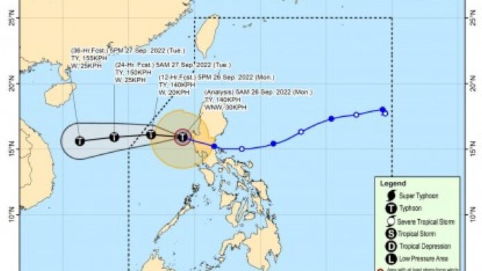
Tropical Cyclone Wind Signal (TCWS) No. 2 was hoisted over parts of Luzon as Typhoon Karding (international name Noru) further moves away from the island, the weather bureau said Monday.
These areas are the western section of Pangasinan (Bolinao, Bani, City of Alaminos, Anda, Sual, Labrador, Mabini, Agno, Burgos, Dasol, Infanta, Bugallon, Lingayen, Aguilar) and the northern portion of Zambales (Santa Cruz, Candelaria, Masinloc, Palauig, Iba)
Gale-force conditions remain possible within any of the areas under Signal No. 2.
Signal No. 1 remains hoisted over La Union, the rest of Pangasinan, the southern portion of Benguet (Sablan, La Trinidad, Itogon, Baguio City, Tuba, Kapangan, Tublay), the rest of Zambales, the northern portion of Bataan (Bagac, City of Balanga, Abucay, Samal, Morong, Orani, Hermosa, Dinalupihan), Tarlac, Pampanga, and the western portion of Nueva Ecija (Cabiao, San Isidro, Jaen, San Antonio, Lupao, Science City of Muñoz, Santo Domingo, Talavera, Aliaga, Zaragoza, Cuyapo, Talugtug, Nampicuan, Guimba, Licab, Quezon).
Strong breeze to near gale strength may still be experienced in any of these areas.
“Karding” was last spotted 190 kilometers west of Dagupan City, Pangasinan. It packs maximum sustained winds of 140 kms. per hour near the center and gustiness of up to 170 kph.
The typhoon is forecast to exit the Philippine Area of Responsibility Monday night.
Moderate to heavy with at times intense rains will prevail over Zambales, Bataan and Lubang Islands.
Light to moderate with at times heavy rains will be experienced over the western portion of Pangasinan.
Scattered flooding and rain-induced landslides are still possible, especially in areas highly susceptible to these hazards.
Meanwhile, rough to very rough seas will prevail over the western seaboard of Northern Luzon (Ilocos Sur, La Union, Pangasinan) and Central Luzon (Zambales, Bataan).
Fishing boats and other small seacraft are advised not to venture out into the sea while larger sea vessels are alerted against big waves. (PNA)


