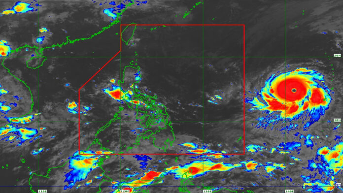
The government is taking the appropriate steps as the country braces for the possible effects of Super Typhoon Mawar on the country, President Ferdinand R. Marcos Jr. assured the public on Thursday.
In a Facebook post, Marcos said the government continues to monitor the situation and updates on the expected onslaught of Mawar as it moves closer to the Philippine Area of Responsibility (PAR).
“Patuloy nating tinututukan ang Super Typhoon Mawar na inaasahang papasok sa Philippine Area of Responsibility bukas ng gabi o Sabado ng umaga (We continue to monitor Super Typhoon Mawar which is expected to enter the Philippine Area of Responsibility by Friday night or Saturday morning),” he said.
“Pinaghahandaan din natin ang magiging epekto nito hindi lamang sa hilagang bahagi ng bansa, kundi sa lahat ng lugar na posibleng maapektuhan ng bagyo (We are preparing for its possible effects not only on the northern part of the country but also on areas that might be possibly hit by the typhoon),” Marcos added.
Marcos noted that in a meeting with Defense Secretary Carlito Galvez Jr., he was assured that the national government and local government units (LGUs) are ready to provide assistance to areas where Mawar may wreak havoc.
“Siniguro natin na naka pre-position ang pondo at food packs, naka-standby ang response teams, at handa na ang mga LGU sa mga lugar na tatamaan ng bagyo (We made sure that funds and food packs have already been prepositioned, response teams are on standby, and LGUs are ready to assist the areas that might be hit by the typhoon),” he said.
Mawar has maintained its strength and its “much closer approach” to the Philippines is possible, according to the 11 a.m. weather bulletin issued by the Philippine Atmospheric, Geophysical and Astronomical Services Administration (PAGASA).
Mawar was last spotted 2,065 km east of southeastern Luzon, packing maximum winds of up to 185 km per hour near the center and gustiness of up to 230 kph.
Moving west at 10 kph, Mawar may enter PAR by Friday evening or Saturday morning and will be given the local name Betty.
Mawar is forecast to continue intensifying in the next three days and may reach a peak intensity of 215 kph by Sunday.
PAGASA said the typhoon’s rain bands may bring heavy rains over Cagayan Valley between Sunday and Tuesday next week.
Tropical Cyclone Wind Signal may be hoisted in the coming days, as strong to gale-force conditions may be experienced in most areas of the region, except for Batanes-Babuyan Islands area which may have gale to storm-force conditions.
Mawar may also enhance the southwest monsoon, bringing rains over the western parts of Luzon and Visayas beginning Sunday or Monday. (PNA)
Photo credit: Facebook/PAGASA.DOST.GOV.PH


